Ashley Cowie, FSA Scot. First published December 16, 2018. Revised edition November 18, 2026.
 https://orcid.org/0000-0001-6872-4759
Abstract. In 2018 the author suggested that two busts, at Alaise and Myon in eastern France, mark a line aimed at the midwinter sunrise. Alaise is the village that nineteenth-century scholars put forward as Alesia, where Caesar defeated the Gauls. This revised study tests the idea with modern mapping. The line is real: seven churches, from Mesmay in France to Ursins in Switzerland, sit almost exactly on one straight line 72 km (45 miles) long, and the church at Ursins stands on a Gallo-Roman temple. But the line misses the solstice sunrise by more than 4°. Instead, the Sun rises and sets along it about a month either side of the solstices, close to the feast days of two of the churches’ own saints, St Martin and St Mary Magdalene, but not to any Celtic festival. From Alaise, the midwinter Sun sets into the Mont Poupet massif. The study treats the alignment as an open question and sets out the fieldwork needed to settle it.
Keywords: Alaise; Alesia; Franche-Comté; archaeoastronomy; church alignments; Xavier Guichard; Mont Poupet; winter solstice
1. Introduction
The siege of Alesia in 52 BCE ended the largest Gallic revolt against Rome, and it holds a central place in French national memory. [1] [2] For more than a century after 1855, its location was disputed, and the village of Alaise in the Doubs was the most persistent rival to Alise-Sainte-Reine in Burgundy. [3]
This paper begins from an observation first published by the author in 2018. The bronze busts of two leading advocates of the Alaise thesis, Alphonse Delacroix and Georges Colomb, stand beside the village churches of Alaise and Myon, and the line between them appeared to follow the solstice axis. The 2018 article claimed that this line was solstitial to within a second of arc and that it passed through eight churches. Those claims are tested here with recomputed coordinates and solar azimuths.
Three questions are addressed. First, do the churches lie on a single line, and how closely? Second, does that line match the azimuth of midwinter sunrise or midsummer sunset at this latitude? Third, is the midwinter sunset seen from Alaise marked by Mont Poupet, the highest summit nearby? The case is also placed in the longer history of alignment studies, from Xavier Guichard’s radial “Alesian” lines of 1936 to the statistical critiques of ley-line research. [4]
2. Where Was Alesia?
Figure 1. Lionel Royer, Vercingetorix Throws Down His Arms at the Feet of Julius Caesar, 1899, oil on canvas, Musée Crozatier, Le Puy-en-Velay. The painting shows the Gallic surrender after the siege of Alesia in 52 BCE. Source: Wikimedia Commons.
Caesar describes Alesia as an oppidum of the Mandubii on a high hill, enclosed by Roman siege lines facing both inward and outward. After the failure of a Gallic relief army, Vercingetorix surrendered (Figure 1). [1] Napoleon III’s excavations at Alise-Sainte-Reine in 1861–1865, and a Franco-German program of excavation there in 1991–1997, traced Roman siege works around Mont Auxois, and most archaeologists regard the location as settled. [5]
Alternative locations nonetheless survive outside the academic field. In 2012, BBC News reported the case made for Chaux-des-Crotenay in the Jura, first advanced by the archivist André Berthier. [6] Vidal and Petit have since examined how such claims are presented to the public, and argue that the controversy now persists more as national myth than as a scientific question. [7]
Alaise lies about 126 km (78 miles) southeast of Alise-Sainte-Reine, on a promontory above the Lison valley, and has formed part of the commune of Éternoz since 1973. [8] An earthwork rampart survives at the locality called Le Châtaillon (Figure 2).
Figure 2. The rampart at Le Châtaillon, Alaise (Doubs), the earthwork that Delacroix and his followers took for the defenses of Alesia. Photograph: Phil25, 2009, CC BY-SA 3.0. Source: Wikimedia Commons.
3. Two Advocates of a Comtois Alesia
Alphonse Delacroix (1807–1878) was an architect in Besançon (Figure 3). [9] On November 10, 1855, he presented a paper to the Société d’émulation du Doubs arguing that Alesia was Alaise, and this paper opened the nineteenth-century debate. [3] The historians Jules Quicherat and Ernest Desjardins supported him, but the Commission de topographie des Gaules rejected the Alaise hypothesis and sent its members to Alise-Sainte-Reine instead. [3]
Figure 3. Alphonse Delacroix (1807–1878), architect of the city of Besançon, who proposed Alaise as Alesia in 1855. Portrait, photographer unknown, before 1878, public domain. Source: Wikipedia.
Georges Colomb (1856–1945) was born at Lure in the Haute-Saône and educated at Besançon and the École normale supérieure (Figure 4). He taught natural sciences at the Lycée Condorcet in Paris, became deputy director of the botanical laboratory at the Sorbonne, and, under the pen name Christophe, became a pioneer of the French comic strip. [10] He was also the Alaise thesis’s most durable twentieth-century advocate, setting out his reading of Book VII of Caesar’s Commentaries in L’Énigme d’Alésia (1922). [11] Colomb died at Nyons in the Drôme on January 3, 1945. [10]
Figure 4. Georges Colomb (1856–1945), botanist, comic-strip pioneer under the name Christophe, and advocate of the Alaise thesis, c. 1885. Photograph: Pierre Petit, CC BY-SA 3.0. Source: Wikimedia Commons.
4. What Did Xavier Guichard Claim?
Xavier Guichard (1870–1947) was a police commissioner who rose to direct the Paris Police judiciaire from 1930 to 1936, and a member of the Société préhistorique de France (Figure 5). [12] Georges Simenon later wrote him into the Maigret novels as the detective’s superior. In 1936 he published Eleusis Alesia: Enquête sur les origines de la civilisation européenne, which argued that places bearing names related to Alesia were laid out on a deliberate geometric network. [13]
Figure 5. Xavier Guichard (1870–1947), director of the Paris Police judiciaire and author of Eleusis Alesia (1936), c. 1900–1910. Photograph: unknown author, public domain. Source: Wikimedia Commons.
Guichard proposed 24 straight lines radiating at intervals of 15° from a center in the Alaise district, close to Mont Poupet (Figure 6). He also proposed a prime meridian passing east of Myon, between Alaise and Mont Poupet (Figure 7). [13] He extended the system across Europe, pairing “Alesian” sites in France with Eleusis in Greece by latitude (Figure 8).
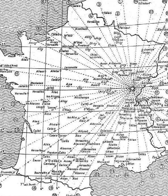
Figure 6. Guichard’s 24 radial alignments centered on the Alaise district, from Eleusis Alesia (1936), p. 326.
Guichard read the name of Eleusis, the Greek sanctuary of the Mysteries near Athens, as another “Alesian” name, and placed it in the same system as Alaise; hence the title of his book, Eleusis Alesiae. The 2018 version of this article repeated his rounded coordinates: 47°00′ N, 5°58′ E for Alaise and 38°00′ N, 18°00′ E for Eleusis. On those figures the two sites appear to differ by a neat 9° of latitude and 12° of longitude. Modern coordinates confirm the first point, since Alaise lies at 47.02° N, 5.97° E. Eleusis, however, lies at 38.04° N, 23.54° E, more than 5° east of the 2018 figure, which falls in the Ionian Sea west of Greece. The true difference in longitude is therefore about 17.6°, not 12°, and only the 9° difference in latitude (8.98°) survives the recomputation. A round-number interval between two places chosen for their names is easily produced by chance, so this survivor carries little weight on its own.
Figure 7. Guichard’s proposed prime meridian, passing east of Myon between Alaise and Mont Poupet. From Eleusis Alesia (1936).
Figure 8. Guichard’s latitude diagram pairing “Alesian” sites in France with Eleusis in Greece. From Eleusis Alesia (1936).
Guichard’s work was popularized in English by Francis Hitching, and it parallels Alfred Watkins’s ley lines in Britain. [14] [15] Archaeologists have largely set it aside, chiefly because the method selects points by sound of name and then looks for lines among them. Yet two of his choices, the Alaise district and Mont Poupet, recur in the observations below, which is a reason to test his landscape rather than to dismiss it wholesale.
5. The Busts at Alaise and Myon
Figure 9. Bronze bust of Alphonse Delacroix by his grandson, Alphonse Voisin-Delacroix (1857–1893), beside the church of Saint-Jean-Baptiste, Alaise. Photograph: Phil25, 2009, CC BY-SA 3.0. Source: Wikimedia Commons.
A bronze bust of Alphonse Delacroix stands beside the church of Saint-Jean-Baptiste at Alaise, the only such monument in the village (Figure 9). It is the work of his grandson, the sculptor Alphonse Voisin-Delacroix (1857–1893), who first exhibited a bust of his grandfather at the Salon of 1893. [16]
A second bust, a bronze of Georges Colomb, stands at the crossroads beside the neoclassical Church of the Assumption (Église de l’Assomption) at Myon, built from 1843, in the next village to the northwest, 2.8 km (1.7 miles) away (Figure 10). It honors his research and his defense of the local theory that Alesia lay at Alaise, and the street that runs past it bears his name, Rue Georges Colomb. The date and maker of the bust have not yet been traced. Colomb spent his career in Paris and died at Nyons in the Drôme. [17]
Figure 10. The Church of the Assumption at Myon, beside which stands the bust of Georges Colomb. Photograph: Espirat, May 2019, CC BY-SA 4.0. Source: Wikimedia Commons.
The two men championed the same thesis and are commemorated beside neighboring churches. The question this paper asks is whether the line between those two churches carries any astronomical or landscape significance.
6. Research Methodology
Research design. The study is a desk-based re-survey of the 2018 observations, which were made by eye in Google Earth Pro with its ruler tool. Each 2018 claim was restated as a measurable test with a stated tolerance: a positional test of the church line, an astronomical test of the solstice reading, and a horizon test of the Mont Poupet sunset. All figures were recomputed from source coordinates rather than measured on screen.
Data sources. Church positions were taken from the Wikidata items for the buildings themselves, not for the villages, through the Wikidata Query Service on November 18, 2026. [18] Each item was confirmed by name and commune: for example, “église Saint-Jean-Baptiste d’Alaise” and “église Sainte-Brigide de Granges-Narboz”, the church the 2018 text called “Grange d’Église”. Ogens has no church item, so its village coordinates were used and its result is reported as provisional. Elevations came from the Open-Meteo elevation service, which serves the Copernicus GLO-90 digital elevation model at a 90 m (295 feet) grid. [19]
Checking the coordinates. Two checks were made before any bearing was computed. First, independent sources were compared where they exist: the Wikidata position of the church at Ursins agrees with the Vici.org archaeological gazetteer’s position for the Roman temple beneath it to within 2 m (7 feet). [20] Second, church points were compared with village centers to show why village coordinates were not used: the village center lies 73 m (240 feet) from the church at Myon and 175 m (574 feet) from the church at Alaise, enough to shift a short bearing by several degrees.
Geodesic computation. Bearings and distances were computed on the WGS84 ellipsoid with Karney’s algorithms, as implemented in the GeographicLib library for Python. [21] Each bearing was checked by computing it in both directions: Myon to Alaise gives 120.51° and Alaise to Myon 300.53°, a difference of 180.02°, as expected from the convergence of meridians over 2.8 km (1.7 miles).
Two tests of the alignment. The first test repeats the 2018 method: a line is defined by the churches at Myon and Alaise, extended, and each other church’s perpendicular offset from it is measured. Because that line rests on two points only 2.8 km (1.7 miles) apart, any positional error at Myon or Alaise is magnified along its length. The second test removes that dependence: a single best-fit geodesic was fitted through all seven church positions from Mesmay to Ursins by least squares, and each church’s offset from it was measured. As a cross-check, a straight line was also fitted to the same points in a flat local projection by total least squares.
Positional error budget. Wikidata church coordinates are assumed accurate to about 10–20 m (33–66 feet), the size of a village church. On the 2.8 km (1.7 miles) Myon–Alaise baseline, errors of that size give a bearing uncertainty of ±0.3–0.6°, and an offset uncertainty of ±330–650 m (±0.2–0.4 miles) at Ursins, 64 km (40 miles) away. Offsets in the first test beyond L’Auberson therefore cannot be read closely; the second test is the reliable measure.
Solar model. Rising and setting azimuths were computed for latitude 47.01° N from cos A = (sin δ − sin φ sin h) / (cos φ cos h), where A is the azimuth, δ the Sun’s declination, φ the latitude and h the altitude of the Sun’s center. The solstitial declination was taken as −23.44° for the present and −24.0° for c. 3000 BCE, allowing for the slow change in the tilt of the Earth’s axis. A flat horizon was modeled at h = −0.83°, which allows for refraction and the Sun’s semidiameter; raised horizons of 1–3° were modeled with standard refraction values. [22]
Horizon and terrain. Horizon altitudes were first estimated from elevation profiles sampled every 400 m (1,300 feet) along each azimuth. Near the churches the 90 m (295 feet) terrain cells blur the valley sides, and the profiles gave unstable results, for example an apparent 5.4° skyline only 1.5 km (0.9 miles) from Myon. The horizon was therefore bracketed between 0° and 3° rather than fixed, and every solar result is reported as a range. The same terrain grid, about 2,000 points, was used to shade the relief in Figures 12 and 14.
Reproducibility. All calculations were run in Python, and the maps and diagrams in Figures 11, 12 and 14 were drawn from the same data. The coordinate table is given in the Appendix, and the scripts are deposited with the paper’s Zenodo record.
7. Does the Myon–Alaise Axis Mark the Solstice?
Figure 11. The Myon–Alaise axis (120.5° / 300.5°) compared with midwinter sunrise, midsummer sunset and midwinter sunset at Alaise. Author’s graphic, 2026.
The church at Myon lies on a bearing of 120.51° from the church at Alaise; the reverse bearing is 300.53° (Figure 11). On a flat horizon at this latitude, midwinter sunrise occurs at an azimuth of 124.6° today and 125.6° in c. 3000 BCE, and midsummer sunset at 304.6°. The Jura ridges to the southeast raise the horizon, which moves the sunrise point further south, to about 126.5–129° for a horizon of 1–3°.
The axis therefore misses midwinter sunrise by at least 4°, and probably by 6–9° once the skyline is allowed for. That is eight or more times the Sun’s apparent diameter. A Sun rising at 120.5° corresponds to a declination of about −21°, which it reaches about a month before and a month after the winter solstice. The 2018 claim that the axis is solstitial to within a second of arc is withdrawn.
8. How Far Does the Line Extend?
Figure 12. The axis extended over 76 km (47 miles), from Mesmay (Doubs) to Ogens (Vaud), with the churches that lie on or near it. Author’s graphic, 2026; relief from Open-Meteo.
Extended in both directions, the Myon–Alaise line passes close to a series of churches over 76 km (47 miles), from Mesmay in the Doubs to Ogens in the Swiss canton of Vaud (Figure 12). Offsets from the line, from northwest to southeast, with distance along the line from Myon, are:
Mesmay, Sainte-Madeleine: 127 m (417 feet)
Myon, Assumption, and Alaise, Saint-Jean-Baptiste: on the line by definition
Levier, Saint-Jean-Baptiste: 53 m (174 feet), at 16 km (10 miles)
Granges-Narboz, Sainte-Brigide: 178 m (584 feet), at 32 km (20 miles)
L’Auberson: about 176 m (577 feet), at 46 km (28 miles)
Ursins, Saint-Martin: 516 m (1,690 feet), at 64 km (40 miles)
Ogens: about 650 m (2,130 feet), at 68 km (42 miles), village center
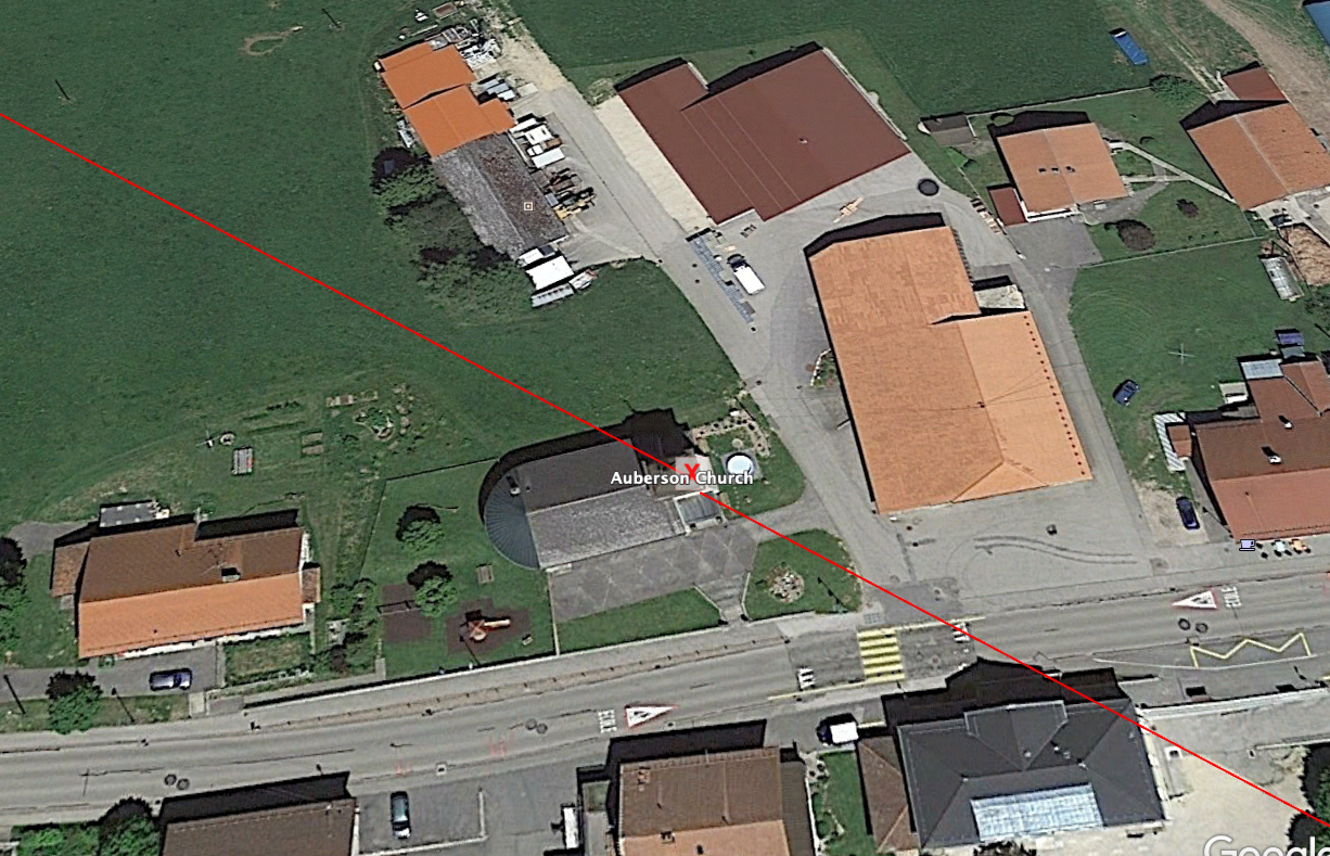
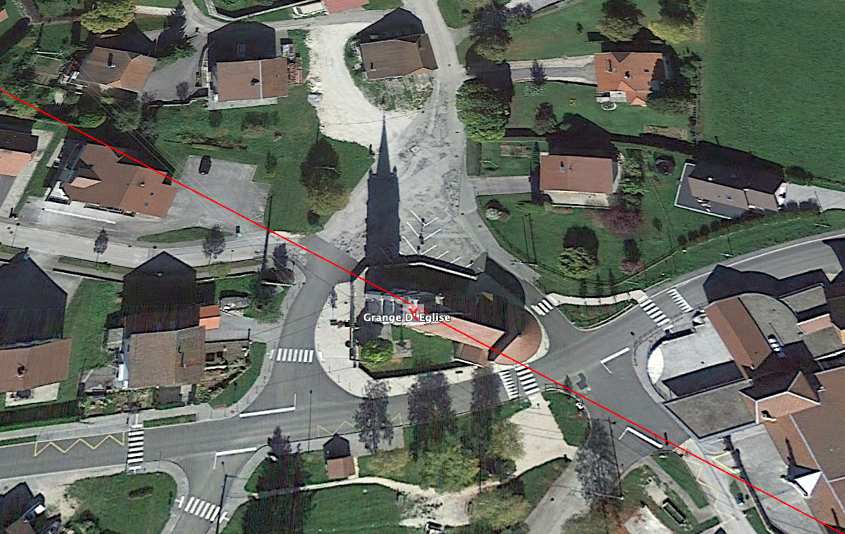
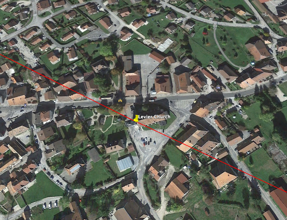
Figure 13. The axis crossing the churches of Levier, Granges-Narboz and L’Auberson. Author’s graphic on Google Earth Pro imagery, 2018.
Five churches between Mesmay and Granges-Narboz lie within about 180 m (590 feet) of a single line over 40 km (25 miles), and the line crosses the buildings at Levier, Granges-Narboz and L’Auberson (Figure 13). The deviation grows beyond L’Auberson, and the line drifts by about 0.5 km (one-third of a mile) at Ursins.
The second test gives a tighter result. A single best-fit geodesic through all seven churches from Mesmay to Ursins, 72 km (45 miles) long, leaves a root-mean-square offset of 59 m (194 feet). The largest offset is 127 m (417 feet), at Levier, and Ursins lies only 42 m (138 feet) from the fitted line. The fitted line bears 120.0° at Myon and Alaise, turning to 120.6° at Ursins as the meridians converge. A flat-projection fit to the same points gives a root-mean-square offset of 47 m (154 feet), which agrees. The larger offsets at Ursins in the first test therefore come from the short Myon–Alaise baseline, not from the churches.
Ursins is the most significant point on the line. Its church of Saint-Martin, rebuilt in 1702, stands on the podium of a Gallo-Roman temple, a fanum excavated in 1908–1910 and again in 1988. An inscription records the rebuilding of a temple to Mars Caturix. [23] Here, at least, a Christian church demonstrably succeeds a pagan sanctuary.
9. Does the Midwinter Sun Set into Mont Poupet?
Figure 14. From Alaise, the midwinter Sun sets into the Mont Poupet massif to the southwest (bearing 231–235°). Author’s graphic, 2026; relief from Open-Meteo.
Seen from the church at Alaise, the summit of Mont Poupet, at 851 m (2,792 feet), lies at a bearing of 235.3° and a distance of 8.1 km (5.0 miles). The Croix du Poupet, at the southern end of the same massif, lies at 230.8°. Midwinter sunset on a flat horizon occurs at 235.4°, and behind a skyline raised 1–3° by the massif itself it occurs at about 231–234°.
The midwinter Sun therefore sets into the Mont Poupet massif as seen from Alaise, between the summit and the Croix du Poupet (Figure 14). This result holds within the uncertainty of the horizon. It is the one astronomical claim of the 2018 article that the recomputation supports, and it concerns the same summit that stands near the center of Guichard’s system.
10. If Not the Solstice, Which Date?
If the axis does not mark the solstice, it may still mark a day. Using the solar model of Section 6 and the Sun’s positions for 2026, the Sun rises on the axis at 120.5° about a month either side of the winter solstice. It sets on the reverse bearing, 300.5°, about a month either side of the summer solstice. Because the skyline has not been surveyed, each date is a window of about a week:
Sunrise at 120.5°, looking southeast: November 26 and January 16 on a flat horizon; November 14–20 and January 22–28 behind a 1–3° Jura skyline.
Sunset at 300.5°, looking northwest: May 18 and July 25 on a flat horizon; May 24–29 and July 15–20 behind a 1–2° skyline.
These windows fall 25–37 days from the nearest solstice. The question is whether any of them carried meaning for the people who built the churches.
The Christian calendar. Several fixed feasts fall inside the windows. In late November they include the Presentation of the Virgin (November 21), St Cecilia (November 22) and St Catherine of Alexandria (November 25). In late January they include St Sebastian (January 20), St Agnes (January 21) and St Vincent (January 22). In late July they include St Mary Magdalene (July 22). [24] St Vincent is the patron of vine growers, and his feast is still celebrated in the wine villages of Burgundy and the Jura on or near January 22. [25]
Because almost every day of the year carries a saint’s feast, any window of a week or more will contain several, and a list of feasts proves little on its own. A stricter test asks whether a church’s own patron falls in that church’s own window. Two churches pass it. Mesmay, at the northwest end of the line, is dedicated to St Mary Magdalene, whose feast on July 22 falls inside the summer sunset window. Ursins is dedicated to St Martin, whose feast falls on November 11.
The calendar change. The test depends on which calendar the founders used. The Julian calendar ran 7 days behind the solar year in the twelfth and thirteenth centuries and 8 days behind in the fourteenth and fifteenth. France adopted the Gregorian calendar in December 1582; the Protestant cantons of Switzerland, including Vaud, followed in January 1701. [26] In the Julian calendar of the high Middle Ages, Martinmas (November 11) fell on the solar day that is now November 18–19, inside the sunrise window. In the same calendar, the Magdalene’s feast fell on what is now July 29–30, outside the sunset window. Mesmay therefore matches only if its dedication was fixed under the Gregorian calendar, and Ursins only under the Julian. No single calendar makes both churches match, and the foundation dates of both dedications are unknown.
The Celtic calendar. No Celtic festival fits. The quarter days of the insular Celtic year, Samhain, Imbolc, Beltane and Lughnasadh, fall at the beginning of November, February, May and August, about 45 days from the solstices rather than 30. [27] The Gaulish calendar itself, known from the bronze tablet found at Coligny, was lunisolar: its months followed the Moon, so its festivals did not sit on fixed solar dates. [28] Granges-Narboz is dedicated to St Brigid, whose feast on February 1 coincides with Imbolc, but that is a fact about the dedication, not the alignment, and it falls outside the January window.
The date test therefore gives a suggestive but unproven result. Two of seven churches can be matched to their own patron’s feast, each only under one calendar. A field observation of sunrise from Myon in late November and late January would fix the actual dates and so narrow the windows on which this test depends.
11. Comparative Context
The closest parallels to the Myon–Alaise line come not from prehistoric monuments but from studies of how churches themselves were oriented. In 1822 William Wordsworth wrote that a church faced the sunrise on the feast day of its patron saint, and the idea has been tested many times since. Ali and Cunich, measuring major English churches of the eleventh and twelfth centuries, found that it might hold for as many as 43 percent of them if both sunrise and sunset are allowed. [29] Hinton’s survey of almost 1,500 rural churches found no such link: churches dedicated to saints with summer feast days face the same way as those with winter feasts. [30] Hinton has since extended his survey to more than 2,000 rural churches and, in an interview with the author on the History Fuzz Podcast, argued that local weather and climate, more than saints’ days, shaped the orientation of English churches. [31] Both studies test the axis of each building. The present case is different, because the patron feasts at Mesmay and Ursins fall in the weeks when the Sun follows a line between churches, not the axis of any one of them.
A second parallel comes from Gaul itself. Graham Robb has argued that the Via Heraklea, an ancient route from Iberia to the Alpine pass of Montgenèvre, runs straight along the solstice bearing (summer sunrise one way, winter sunset the other), and that Gallic towns and sanctuaries were laid out on a network of solstice lines. [32] His reviewers objected that enough straight lines drawn across a dense map will always produce such coincidences. That is the same objection that applies to Guichard’s 24 lines and to the line studied here.
Both parallels point to the same test. A built axis, such as a church nave, can be measured and compared with the sky. A line drawn between villages is a different kind of object: it needs evidence that its points were placed with reference to one another, and not picked out of a dense landscape after the line was drawn.
12. Discussion and Limitations
Chance alignment. The Jura plateau is dense with villages and churches, and near-alignments of random points occur far more often than intuition suggests. [33] [4] Without a test against all church positions in the region, the five-church line cannot be distinguished from chance.
Dating. Most of the churches are medieval or modern rebuildings, and their foundation dates are not established here. Only Ursins demonstrates continuity with a Roman-period sanctuary. Nothing yet links any point on the line to the Iron Age or the Neolithic.
The busts. The busts date from the late nineteenth and twentieth centuries. Their placement reflects modern commemoration of the Alaise thesis and cannot, on its own, show ancient design.
Horizon. The local skyline was modeled, not surveyed. Field readings at sunrise and sunset on December 21 are needed to fix both the sunrise miss and the Poupet sunset.
Ogens. The Ogens point is a village center and should be replaced with the church position.
An alternative reading. The line runs close to Pontarlier and ends in the Yverdon district, both on the historic road over the Jura between the Doubs valley and Lake Neuchâtel. A route-following explanation should be tested alongside an astronomical one.
13. Conclusion
This study tested three claims made for the Myon–Alaise axis in 2018. The first holds, and more strongly than in 2018: seven churches from Mesmay to Ursins lie on a single line 72 km (45 miles) long, none more than 127 m (417 feet) from it and with a root-mean-square offset of 59 m (194 feet). At its southeast end, the church at Ursins stands on a Gallo-Roman temple of Mars Caturix.
The second claim does not hold. The axis bears 120.5°, at least 4° north of the midwinter sunrise at this latitude and probably 6–9° once the Jura skyline is allowed for, so it is not a solstice axis. The third claim holds within the uncertainty of the horizon: from Alaise, the midwinter Sun sets into the Mont Poupet massif, the same summit at the center of Xavier Guichard’s system.
If the axis marks a day, it is not the solstice. The Sun rises on it in mid to late November and late January, and sets on it in late May and mid to late July, 25–37 days from the solstices. No Celtic quarter day falls in these windows. Two churches, however, can be matched to the feast of their own patron: Mesmay to St Mary Magdalene on July 22 under the Gregorian calendar, and Ursins to St Martin on November 11 under the medieval Julian calendar. No single calendar makes both match, so the result is suggestive rather than proven.
The paper therefore proposes the Myon–Alaise line as an open question rather than a solved one. Three tests could resolve it: a statistical comparison with all church positions on the Jura plateau; a field survey of the horizon at Alaise and Myon at the December solstice and on the late-November and late-January sunrise dates; and an archival search for the foundation dates of the churches and for the decision to place Colomb’s bust at Myon.
Appendix: Coordinates Used
WGS84 decimal degrees, from Wikidata church items (accessed November 18, 2026) unless stated. Distance is measured from Mesmay church along the line.
Mesmay, Sainte-Madeleine: 47.061753° N, 5.850857° E · 0 km (0 mi)
Myon, Assumption: 47.026237° N, 5.942454° E · 8.0 km (5.0 mi)
Alaise, Saint-Jean-Baptiste: 47.013545° N, 5.973936° E · 10.8 km (6.7 mi)
Levier, Saint-Jean-Baptiste: 46.953568° N, 6.120855° E · 23.8 km (14.8 mi)
Granges-Narboz, Sainte-Brigide: 46.879250° N, 6.309400° E · 40.4 km (25.1 mi)
L’Auberson (Sainte-Croix): 46.818070° N, 6.462970° E · 53.9 km (33.5 mi)
Ursins, Saint-Martin: 46.735390° N, 6.668250° E · 72.1 km (44.8 mi)
Ogens, village center (no church item): 46.716667° N, 6.716667° E · 76.3 km (47.4 mi)
Mont Poupet, summit: 46.972222° N, 5.886944° E
Croix du Poupet: 46.963920° N, 5.885210° E
Notes
Caesar, Gallic War, 7.68–89.
Boucheron, France in the World.
Ministère de la Culture, “The Alesia Question.”
Robb, Graham. The Ancient Paths: Discovering the Lost Map of Celtic Europe. London: Picador, 2013.
Route des Communes. “Myon.” Accessed November 19, 2026. https://www.routedescommunes.com/doubs/saint-vit/myon.
Wikipedia. “Église de l’Assomption de Myon.” Accessed November 19, 2026. https://fr.wikipedia.org/wiki/%C3%89glise_de_l%27Assomption_de_Myon.
Williamson and Bellamy, Ley Lines in Question.
Reddé and von Schnurbein, Alésia.
Schofield, “France’s Ancient Alesia Dispute Rumbles On.”
Vidal and Petit, “Alésia,” 66–78.
Wikipédia, “Alaise.”
Brocard and Brunet, Alphonse Delacroix.
Encyclopædia Universalis, “Christophe.”
Colomb, L’Énigme d’Alésia.
Bibliothèque nationale de France, “Guichard, Xavier (1870–1947).”
Guichard, Eleusis Alesia.
Hinton, Ian. “Church Alignment and Patronal Saint’s Days.” Antiquaries Journal 86 (2006): 206–26.
Hinton, Ian. “Medieval Church Secrets: Exposing the Truth Behind Freemasonry Myths.” Interview by Ashley Cowie. History Fuzz Podcast, May 21, 2024. YouTube video. https://youtu.be/oSCo2qUkpfo.
Hitching, World Atlas of Mysteries, 77–80.
Watkins, Old Straight Track.
Pinette, Alphonse Voisin-Delacroix.
Route des Communes, “Myon”; Wikipédia, “Église de l’Assomption de Myon.”
Wikidata, church items for Mesmay, Myon, Alaise, Levier, Granges-Narboz, Sainte-Croix (L’Auberson) and Ursins.
Open-Meteo, “Elevation API.”
Vici.org, “Ursins, Temple.”
Karney, “Algorithms for Geodesics,” 43–55.
Ruggles, Handbook of Archaeoastronomy; Ruggles, “British Archaeoastronomy,” 68–70.
Fuchs, “Ursins VD et Riaz FR,” 149–158.
Catholic Church, Martyrologium Romanum.
Ali, Jason R., and Peter Cunich. “The Orientation of Churches: Some New Evidence.” Antiquaries Journal 81 (2001): 155–93.
Beaune Office de Tourisme, “Saint-Vincent’s Day Celebration.”
Tøndering, “The Gregorian Calendar.”
Hutton, Stations of the Sun.
Duval and Pinault, Recueil des inscriptions gauloises, vol. 3.
Ali and Cunich, “Orientation of Churches,” 155–93.
Hinton, “Church Alignment and Patronal Saint’s Days,” 206–26.
Hinton, “Medieval Church Secrets.”
Robb, Ancient Paths.
Kendall and Kendall, “Alignments in Two-Dimensional Random Sets of Points,” 380–424.
Bibliography
Beaune Office de Tourisme. “Saint-Vincent’s Day Celebration.” Accessed November 18, 2026. https://www.beaune-tourism.com/to-see-and-do/wine-tourism-experience/top-6-top-wine-themed-events-in-beaune-and-villages/saint-vincents-day-celebration/.
Bibliothèque nationale de France. “Guichard, Xavier (1870–1947).” Authority record. Accessed November 18, 2026. https://catalogue.bnf.fr/ark:/12148/cb110646396.
Boucheron, Patrick, ed. France in the World: A New Global History. New York: Other Press, 2019.
Brocard, Nicole, and Pascal Brunet, eds. Alphonse Delacroix (1807–1878): Un architecte comtois curieux de son siècle. Besançon, n.d.
Caesar, Julius. The Gallic War. Translated by H. J. Edwards. Loeb Classical Library 72. Cambridge, MA: Harvard University Press, 1917.
Catholic Church. Martyrologium Romanum. 2nd ed. Vatican City: Libreria Editrice Vaticana, 2004.
Colomb, Georges. L’Énigme d’Alésia: Solution proposée d’après le livre VII des Commentaires de César. Paris: Armand Colin, 1922.
Duval, Paul-Marie, and Georges Pinault. Recueil des inscriptions gauloises. Vol. 3, Les calendriers (Coligny, Villards d’Héria). Paris: CNRS, 1986.
Encyclopædia Universalis. “Christophe, Georges Colomb dit (1856–1945).” Accessed November 18, 2026. https://www.universalis.fr/encyclopedie/georges-colomb-dit-christophe/.
Fuchs, Michel. “Ursins VD et Riaz FR: Mêmes combats pour Mars Caturix?” Archéologie Suisse 20 (1997): 149–158.
Guichard, Xavier. Eleusis Alesia: Enquête sur les origines de la civilisation européenne. 1936.
Hitching, Francis. The World Atlas of Mysteries. London: Collins, 1978.
Hutton, Ronald. The Stations of the Sun: A History of the Ritual Year in Britain. Oxford: Oxford University Press, 1996.
Karney, Charles F. F. “Algorithms for Geodesics.” Journal of Geodesy 87, no. 1 (2013): 43–55. https://doi.org/10.1007/s00190-012-0578-z.
Kendall, David G., and Wilfrid S. Kendall. “Alignments in Two-Dimensional Random Sets of Points.” Advances in Applied Probability 12, no. 2 (1980): 380–424.
Ministère de la Culture. “The Alesia Question.” Sources de l’archéologie. Accessed November 18, 2026. https://archeologie.culture.gouv.fr/sources-archeologie/en/alesia-question.
Open-Meteo. “Elevation API.” Copernicus DEM GLO-90. Accessed November 18, 2026. https://open-meteo.com/en/docs/elevation-api.
Pinette, Matthieu. Alphonse Voisin-Delacroix ou quand un sculpteur rencontre un céramiste, 1892–1893. Exhibition catalogue. Besançon: Musée des beaux-arts et d’archéologie, 1993.
Reddé, Michel, and Siegmar von Schnurbein, eds. Alésia: Fouilles et recherches franco-allemandes sur les travaux militaires romains autour du Mont-Auxois (1991–1997). Mémoires de l’Académie des Inscriptions et Belles-Lettres 22. Paris: De Boccard, 2001.
Route des Communes. “Myon.” Accessed November 19, 2026. https://www.routedescommunes.com/doubs/saint-vit/myon.
Ruggles, Clive L. N. “British Archaeoastronomy.” In Encyclopedia of Time, edited by Samuel L. Macey, 68–70. New York: Garland, 1994.
Ruggles, Clive L. N., ed. Handbook of Archaeoastronomy and Ethnoastronomy. New York: Springer, 2015.
Schofield, Hugh. “France’s Ancient Alesia Dispute Rumbles On.” BBC News, August 27, 2012. https://www.bbc.com/news/world-europe-19167600.
Tøndering, Claus. “The Gregorian Calendar.” Calendar FAQ. Accessed November 18, 2026. https://www.tondering.dk/claus/cal/gregorian.php.
Vidal, Jonhattan, and Christophe Petit. “Alésia: L’instrumentalisation actuelle d’une prétendue controverse, entre mythe national et théorie du complot.” Canadian Journal of Bioethics 2, no. 3 (2019): 66–78. https://doi.org/10.7202/1066464ar.
Vici.org. “Ursins, Temple.” Archaeological atlas of classical antiquity. Accessed November 18, 2026. https://vici.org/vici/13120/.
Watkins, Alfred. The Old Straight Track. London: Methuen, 1925.
Wikidata. Church items for Mesmay, Myon, Alaise, Levier, Granges-Narboz, Sainte-Croix and Ursins. Accessed November 18, 2026. https://query.wikidata.org.
Wikipédia. “Alaise.” Accessed November 18, 2026. https://fr.wikipedia.org/wiki/Alaise.
Wikipédia. “Église de l’Assomption de Myon.” Accessed November 19, 2026. https://fr.wikipedia.org/wiki/%C3%89glise_de_l%27Assomption_de_Myon.
Williamson, Tom, and Liz Bellamy. Ley Lines in Question. Kingswood: World’s Work, 1983.