Ashley Cowie, FSA Scot. First published May 23, 2018. Revised edition November 20, 2026.
 https://orcid.org/0000-0001-6872-4759
Abstract. Norway built only two medieval copies of the Holy Sepulchre in Jerusalem: the octagon over St. Olav’s grave at Nidaros Cathedral in Trondheim, and the round church in Tønsberg. This article shows that they stand on almost the same north–south line, a fit with only about a 1 in 80 chance of occurring by accident. Measured from St. Clement’s church, the saint’s first shrine, the fit is even closer. The two buildings share a design, and in the 1190s both were held by allied churchmen of the Bagler party. The article asks who could have set out the line, and why: as a spiritual spine for the saint’s kingdom, running beside the pilgrim road to his shrine, or as a baseline for measuring the Earth, of value to the seafaring towns at either end. No document records a survey, so the meridian remains a proposal.
Keywords: Nidaros Cathedral; Tønsberg; St. Olav; Holy Sepulchre; round churches; medieval meridians; Eratosthenes; archaeoastronomy
1. Introduction
King Olav Haraldsson was killed at the Battle of Stiklestad in 1030 and enshrined as a saint at Nidaros, modern Trondheim, the following year. His cult made Nidaros the northernmost great pilgrimage center of medieval Europe, and in the late 12th century an octagon modeled on Jerusalem’s Holy Sepulchre was raised over his grave. [1] Only one other church in medieval Norway copied the Holy Sepulchre: the round church of St. Olav in Tønsberg, on the Oslofjord. [2]
The two buildings share more than a model. Tønsberg’s round church stands almost due south of St. Olav’s shrine, 464 km (288 miles) away across the mountains of southern Norway. This revised edition asks exactly where that line runs, when the two buildings were raised, who controlled them, and why anyone would have wanted them on one meridian.
2. Research Methodology
Positions were taken from the mapped outlines of both buildings rather than from map pins. The center of the Nidaros octagon (63.4269° N, 10.3977° E) was placed half its external diameter of 24.7 m (81 feet) inside the cathedral’s east end. [3] The center of the Tønsberg rotunda (59.2663° N, 10.4101° E) is the center of the excavated ruin at Storgaten 17–19. Distances and azimuths were computed on the WGS84 ellipsoid with the geographiclib library in Python. Positions are reliable to about 20 m (66 feet), which moves the result by about one arc-second. A simple estimate of chance is given in section 9. Historical claims were checked against primary texts and recent scholarship.
3. When Was the Octagon Raised over St. Olav’s Grave?
After Olav’s enshrinement in 1031, his grave became the fixed point of everything built at Nidaros. King Olav Kyrre began a stone church over it around 1070, and when Nidaros became the seat of Norway’s archbishop in 1153, the saint’s grave gave the new province its center. [4] Archbishop Eystein Erlendsson, who died in 1188, began to rebuild the east end in the new Gothic style. The octagon around the grave was traditionally dated to his return from exile in 1183; recent work places its start around 1200 and its completion around 1210–15. [5]
Figure 1. Nidaros Cathedral, Trondheim, from the northeast, 1857. Source: Wikimedia Commons.
The octagon’s high altar stood over the grave, as Christ’s tomb stands at the center of the rotunda in Jerusalem, and the shrine of the saint stood behind it. [6] The position matters for this article. The octagon could not be moved: it was built where the saint had lain since 1031. If the meridian was intended, it was Tønsberg’s builders who placed their church in relation to the grave.
4. Why Did Tønsberg Build a Round Church?
Tønsberg, on the west side of the Oslofjord, was one of Norway’s oldest towns and a royal center. St. Olav’s church stood at the end of Storgaten, the town’s long street, and belonged to an abbey of Premonstratensian canons. The canons are first mentioned in 1191, when Danish crusaders bound for the Holy Land stayed in the town. [7] The church certainly stood by 1207, when the Bagler king Erling Steinvegg was buried by its altar. [8] It is usually dated to about 1170–90, although it could be older. It is the only medieval round church known in Norway and the largest in Scandinavia, about 25–27 m (82–89 feet) across outside and 22–23 m (72–75 feet) inside. [9]
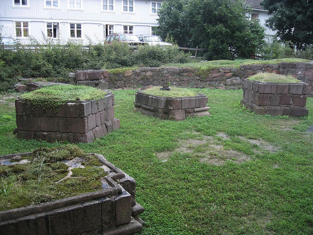
Figure 2. Ruins of St. Olav’s round church, Tønsberg. Photograph: Karl Ragnar Gjertsen, CC BY-SA 3.0. Source: Wikimedia Commons.
Round churches across Europe copied the rotunda of the Holy Sepulchre. Scandinavia has 34 known examples, including four on the Danish island of Bornholm. [10] Most belong to what historians call the round church movement, a wave of circular churches built between the 1130s and about 1190, in the decades after the First Crusade. [11] Jes Wienberg of Lund University argues that round churches need no special explanation beyond elite patronage and the symbolic copying of Jerusalem. In Norway, as Bjørn Bandlien notes, the fashion never spread beyond Tønsberg and Nidaros. [12]
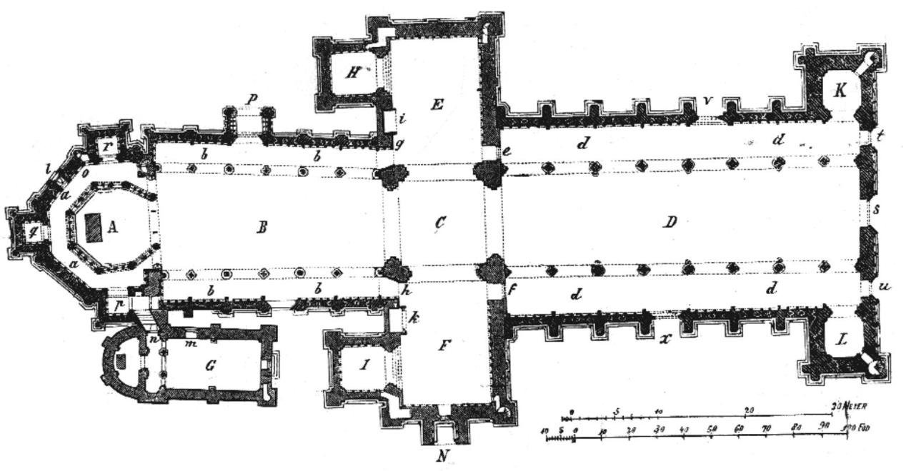
Figure 3. Ground plan of Nidaros Cathedral, Trondheim, with the octagon over St. Olav’s grave (A) at the east end, on the left. From O. Krefting, Om Throndhjems Domkirke, 1885. Source: Wikimedia Commons.

Øystein Ekroll of the Nidaros Cathedral Restoration Workshop has shown that the two Norwegian buildings copy the same model. Tønsberg’s nave matches the arcade of the Jerusalem rotunda, and its external diameter at ground level is “virtually identical” to that of the Nidaros octagon. [13] The two most ambitious St. Olav buildings of their age were built to one Jerusalem model.
5. Do Norway’s Two Holy Sepulchres Share a Meridian?
Ekroll’s measurements show the two buildings were designed on one model, [13] and Wienberg suggests that the same Bagler churchmen may have commissioned both. [8] Measured from the center of the Nidaros octagon, the round church in Tønsberg lies 464 km (288 miles) away on an azimuth of 179.91°, only 5 arc-minutes from due south. The two longitudes differ by 45 arc-seconds, about 0.71 km (0.44 miles) on the ground. To an observer timing the Sun’s noon crossing, the difference is 3 seconds: the Sun stands due south over the shrine and over the rotunda at virtually the same moment.
Figure 4. The St. Olav meridian: Nidaros Cathedral and St. Olav’s church, Tønsberg, 464 km (288 miles) apart on one meridian. Graphic: History Fuzz.
6. Where Did the Line Begin?
The octagon may not be where the line begins. St. Olav built St. Clement’s church in Trondheim around 1015, and in 1031 his body was enshrined above its altar, his first shrine. [14] The church, excavated in 2016–17, stands 540 m (590 yards) north of the octagon. Measured from the excavated site, Tønsberg’s round church lies 464 km (288 miles) away on an azimuth of 179.94°. That puts it within 33 arc-seconds of the same meridian, or 0.52 km (0.32 miles) on the ground, a closer fit than from the octagon. St. Clement’s is older than both Norwegian copies of the Holy Sepulchre by more than 150 years. A line carried south from the saint’s own church would reach Tønsberg within about half a kilometer of the round church. The octagon could not have been placed that way, because it stands over the grave Olav was buried in.
Between Trondheim and Vestfold, the line was tested against every church in Wikidata founded before 1550, in a band about 5 km (3 miles) either side of the meridian. [15] Across about 400 km (250 miles) of mountain and forest, it passes within 1 km of none of them. Only on reaching the densely settled shores of the Oslofjord does it come near other medieval churches: the parish churches of Røyken, Nykirke and Sem lie 0.6–0.8 km (0.4–0.5 miles) to the west, and Nøtterøy 0.5 km (0.3 miles) to the east. The line does not gather churches along its course. It joins the saint’s first church and his grave at one end to the round church at the other, which supports the reading that its ends were chosen rather than found.
The record has limits. Wikidata’s founding dates are incomplete and are often rounded to the century, and no written source records a survey from St. Clement’s. Section 9 returns to these limits.
7. Who Could Have Set the Line, and When?
The 1190s offer the clearest moment when both ends of the line lay in the same hands. Eirik Ivarsson was archbishop of Nidaros from 1189 to 1205. [16] Tønsberg lay in the diocese of Oslo, whose bishop from 1190 to 1225 was Nicholas Arnesson. In 1196 the two churchmen founded the Bagler party against King Sverre. [17] The Bagler made Tønsberg a stronghold and held its castle rock against Sverre’s siege for 20 weeks in 1201–02. [18] Wienberg suggests that Bishop Nicholas may have founded the round church and abbey in the 1190s, and that the Bagler leaders may have commissioned both Norwegian copies of the Holy Sepulchre. [19]
The dating does not decide the question either way. If the round church is older, as Ekroll prefers, its builders could still have placed it in relation to the saint’s grave, which had been fixed since 1031. If it belongs to the 1190s, it was raised by the same party that held Nidaros while the octagon was being planned.
8. Why Would Anyone Want a Meridian?
Two explanations are possible, and they are not exclusive. The first is symbolic. Olav was venerated as rex perpetuus Norvegiae, the eternal king of Norway. [20] A line running due south from his grave to the kingdom’s second copy of the Holy Sepulchre would form a spiritual spine for the realm, tying the south-eastern province of Viken to the saint, and both to Jerusalem. The kingdom already had such a spine on the ground. The main medieval pilgrim road ran from Oslo up the Gudbrandsdal valley and over the Dovre mountains to the shrine. It runs close to the meridian for its whole length, crossing it near Lake Mjøsa and never straying more than about 60 km (40 miles) from it. [21] Medieval churchmen did place churches to express a sacred plan. In 11th-century Utrecht, Bishop Bernold built new churches around his cathedral that, with a later church, form a cross on the map, although scholars still debate whether the cross was planned. [22] The St. Olav meridian would be the same idea on the scale of a kingdom, and no other example of that scale is known.
Figure 5. The St. Olav meridian and the main medieval pilgrim road from Oslo to Nidaros, shown by the modern waymarked Gudbrandsdalsleden. Graphic: History Fuzz.
The second is practical. Around 240 BCE Eratosthenes estimated the size of the Earth by comparing the noon Sun at Alexandria and Syene, which he took to lie on one meridian. The difference in the Sun’s noon altitude between two such stations equals their difference in latitude. Nidaros and Tønsberg differ by 4.16°. Applied to the 464 km (288 miles) between them, that gives an Earth of about 40,100 km (24,900 miles) around, close to the true figure of 40,008 km (24,860 miles). Learned Norwegians knew the Earth was round: in the mid-13th century the author of The King’s Mirror used an apple to argue that it is a sphere. [23]
Figure 6. Eratosthenes’ method applied to the St. Olav meridian: the difference in the noon Sun’s angle at Nidaros and Tønsberg equals the angle between them at the Earth’s center. Graphic: History Fuzz.
Both ends of the line were maritime towns. Nidaros was the kings’ shipyard: Olav Tryggvason built the Long Serpent there in 999, and King Sverre launched the Mariasuden, the largest ship in Norway, there in 1182. [24] Tønsberg lay on the main shipping lane along the Norwegian coast, joined the foreign trade network early and became a royal stronghold. [25] Norse mariners crossed open sea by latitude sailing, judging north and south from the height of the noon Sun or the Pole Star, and had no means of finding longitude. [26] For such sailors, a measured stretch of meridian would have had real value, because it turns a change in the Sun’s height into a distance. No source shows that captains or shipowners used one.
The difficulty is the method. A 12th-century observer could fix latitude from the noon Sun or the Pole Star with fair accuracy. Longitude is another matter, because it can only be found by comparing times. The Earth turns 360° in 24 hours, so local noon moves west by 15° every hour, or 15 arc-seconds every second. Tønsberg lies 45 arc-seconds east of the shrine, so its noon falls 3 seconds earlier. To set out the line by the Sun, a surveyor would have had to compare two noons 464 km (288 miles) apart to within a few seconds, far beyond any medieval clock. A direct sight line was no easier: the route crosses mountains, forests and lakes. No known 12th-century technique could have laid out the line to this precision.
9. Discussion and Limitations
A meridian alignment of under one arc-minute between the only two Holy Sepulchre copies in Norway is striking, but striking is not proof. A simple estimate gives a sense of the odds. If the round church could have stood anywhere across Viken, roughly 2° of longitude from Skien to the Swedish border, the chance of it falling within 45 arc-seconds of the shrine’s meridian is about 1 in 80. The estimate is generous to the hypothesis in one respect: Tønsberg itself is far older than its round church, so the builders could choose a site only within the town, a span of roughly 1 km (0.6 miles) from east to west.
Wienberg’s caution stands: round churches can be explained without mystery, and no document records a survey between Nidaros and Tønsberg.
A first test against the population was run for this edition. Wikidata lists 197 churches in Norway with a recorded founding date before 1550. [15] Across 1,151 meridians spaced 0.01° apart between 5° E and 16.5° E, an average meridian passes within 0.71 km (0.44 miles) of fewer than one of them. The shrine’s meridian passes that close to six: three in Trondheim, and three near Tønsberg at Nøtterøy, Sem and Røyken. Without Trondheim, three remain, a count matched or beaten by about one meridian in 29. The line is unusually rich in medieval churches, but the three near Tønsberg show that along the densely settled Vestfold coast, a church within 0.7 km of it is not rare. What sets the round church apart is not its distance from the line but its form, as one of only two copies of the Holy Sepulchre in Norway. The test has limits: Wikidata records only a fraction of Norway’s medieval churches, mostly those that survive, and the round church itself is not among its dated entries.
10. Conclusion: Was the Meridian Surveyed?
Norway’s two copies of the Holy Sepulchre stand 464 km (288 miles) apart and within 45 arc-seconds of the same meridian. They copy one model, share almost the same diameter, and in the 1190s both lay in the hands of the Bagler churchmen. Measured from St. Clement’s, the saint’s first shrine and the oldest of the three buildings, the fit is closer still, and across the 400 km (250 miles) between Trondheim and Vestfold the line meets no other medieval church. The line could have expressed the reach of the eternal king’s kingdom, or served as a baseline for measuring the Earth by the method of Eratosthenes. In that sense the churches would have been navigation tools at one remove: not marks for sailors, but the two ends of a measured stretch of meridian, from which the length of a degree, and so distances at sea, could be reckoned. It may also be chance, at odds of about 1 in 80. A first population test finds the line unusually rich in medieval churches. Until a written source is found, the St. Olav meridian remains a hypothesis: too close to dismiss, too early to prove.
Notes
Ekroll, “St Olav and the Octagon.”
Bandlien, “The Premonstratensians,” 111–12.
Ekroll, “The Round Church of Tønsberg,” 69.
Ekroll, “The Octagonal Shrine Chapel of St Olav.”
Ekroll, “The Round Church of Tønsberg,” 68–69.
Ekroll, “The Round Church of Tønsberg,” 67–68, 71.
Ekroll, “The Round Church of Tønsberg,” 58.
Wienberg, “Jerusalem in Tønsberg,” 81–110.
Ekroll, “The Round Church of Tønsberg,” 58–59; Wienberg, “Jerusalem in Tønsberg,” 81–110; Lunde, “St Olav’s Church in Tønsberg,” 33–56.
Wienberg, “Iøjnefaldende arkitektur,” 205–44.
Bandlien, “The Premonstratensians,” 111–12.
Wienberg, “Jerusalem in Tønsberg,” 81–110; Bandlien, “The Premonstratensians,” 111–12.
Ekroll, “The Round Church of Tønsberg,” 73, 77.
Norwegian Institute for Cultural Heritage Research, “Church and Altar of Viking King Olaf Haraldsson.”
Wikidata, churches founded before 1550, queries of November 20, 2026.
Store norske leksikon, “Eirik Ivarsson.”
Store norske leksikon, “Nikolas Arnesson.”
Store norske leksikon, “Tunsberghus.”
Wienberg, “Jerusalem in Tønsberg,” 81–110.
Ekroll, “The Round Church of Tønsberg,” 57.
Pilegrimsleden, “Gudbrandsdalsleden.”
Mekking and van Berkum, “Het kerkenkruis voor de rechter.”
Larson, The King’s Mirror, chap. 7.
Nicolaysen, Langskibet fra Gokstad.
Brendalsmo and Molaug, “To norske byer i middelalderen.”
Thirslund, Viking Navigation.
Bibliography
Bandlien, Bjørn. “The Premonstratensians and Their Round Church in Tønsberg: Scandinavian Contexts and European Networks.” In Jerusalem in Viken, edited by Bjørn Bandlien, 111–60. Oslo: Cappelen Damm Akademisk, 2023. https://doi.org/10.23865/noasp.189.ch5.
Brendalsmo, Jan, and Petter B. Molaug. “To norske byer i middelalderen – Oslo og Tønsberg før ca. 1300.” Collegium Medievale 27 (2015).
Ekroll, Øystein. “The Octagonal Shrine Chapel of St Olav at Nidaros Cathedral.” PhD diss., Norwegian University of Science and Technology, 2015. https://ntnuopen.ntnu.no/ntnu-xmlui/handle/11250/2372702.
Ekroll, Øystein. “St Olav and the Octagon of Nidaros Cathedral in Trondheim – a Nordic Martyrion?” Acta ad archaeologiam et artium historiam pertinentia 27 (2017). https://journals.uio.no/acta/article/view/5810.
Ekroll, Øystein. “The Round Church of Tønsberg and the Octagon of Nidaros.” In Jerusalem in Viken, edited by Bjørn Bandlien, 57–79. Oslo: Cappelen Damm Akademisk, 2023. https://doi.org/10.23865/noasp.189.ch3.
Larson, Laurence Marcellus, trans. The King’s Mirror (Speculum Regale – Konungs Skuggsjá). New York: American-Scandinavian Foundation, 1917.
Lunde, Øivind. “St Olav’s Church in Tønsberg: The Excavation of 1969–70 in Retrospect.” In Jerusalem in Viken, edited by Bjørn Bandlien, 33–56. Oslo: Cappelen Damm Akademisk, 2023. https://doi.org/10.23865/noasp.189.ch2.
Mekking, Aart J. J., and Aug. van Berkum. “Het kerkenkruis voor de rechter.” Maandblad Oud-Utrecht 62 (1989): 52–56, 81–86.
Nicolaysen, N. Langskibet fra Gokstad ved Sandefjord. Kristiania: Cammermeyer, 1882.
Norwegian Institute for Cultural Heritage Research (NIKU). “Archaeologists in Norway Find the Church and Altar of Viking King Olaf Haraldsson.” 2016. https://www.niku.no/en/?p=1024.
Pilegrimsleden (National Pilgrim Centre). “Gudbrandsdalsleden.” https://pilegrimsleden.no/en/trails/gudbrandsdalsleden.
Store norske leksikon. “Eirik Ivarsson.” https://snl.no/Eirik_Ivarsson.
Store norske leksikon. “Nikolas Arnesson.” https://snl.no/Nikolas_Arnesson.
Store norske leksikon. “Tunsberghus.” https://snl.no/Tunsberghus.
Thirslund, Søren. Viking Navigation. Roskilde: Viking Ship Museum, 2007.
Wienberg, Jes. “Iøjnefaldende arkitektur – Nordens middelalderlige rundkirker.” Kuml 63 (2014): 205–44. https://doi.org/10.7146/kuml.v63i63.24466.
Wienberg, Jes. “Jerusalem in Tønsberg: Round Churches and Storytelling.” In Jerusalem in Viken, edited by Bjørn Bandlien, 81–110. Oslo: Cappelen Damm Akademisk, 2023. https://doi.org/10.23865/noasp.189.ch4.
Wikidata. “Churches with a Recorded Founding Date before 1550: 10.30–10.50° E, and Norway.” Wikidata Query Service, queried November 20, 2026. https://query.wikidata.org/.